What is "Guide Map"?
How to use the "Guide Map"
Shiroishi sightseeing web guide map is a service that allows visitors to see the tour guide map of Shiroishi from PCs and smartphones.
If you have a suitable device (such as a smartphone) that you can use GPS based location information service, display your location information on the guide map and navigate around tourist attractions, useful travel spots, as well as recommended tourist routes .
- How to use
- Press the GUIDEMAP button at the bottom of the page (For smartphone users, go to MENU).
The guide map will be displayed in the browser of your device.
From the model course page, you will see the guide map showing the route of each model course and related spots. When walking on the model course, please use guide map from here

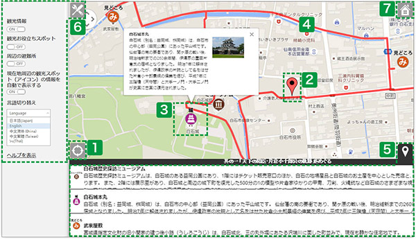
- 1Location tracking button
- Press the button to see your current location. Display can only be shown in devices with GPS function.
- <<How to activate GPS function:(For iPhone users)>>
- Home → Settings → Privacy → GPS → Switch on.
* Home → Setting → GPS for some OS versions
- <<How to activate GPS function:(For Android users)>>
- Settings → Services → Check the "Use GPS" box to switch on the function.
*Operation may be different in different devices / OS
- 2Your curent location
- Your current location as displayed by GPS (global position system)
- 3Spot information
- Sightseeing spots and spot locations are shown by icons.
Tap or click on the icon for basic information about a spot.
When a balloon is displayed, tap or click on the information and see further details.
- 4Route information (only for model course map)
- The model course routes are displayed as red lines. Match your current location with the red lines and follow the course
- 5Spot information tab
- Tap or click on the spot information tab to see the information on the area, and three sites nearest to you will be automatically displayed. Distances to those sites are also shown.
- 6Setting menu
- Tap or click on the settings menu button to see the setting menu.
- You can change the display preferences (sightseeing information or useful information) of the spot on your map in the settings menu.
- By switching the "auto-display spot information" on or off, you can display or hide the information balloon of the spots on your map.
- By switching the language, you can have your map displayed in another language.
- By tapping (clicking) the help button, you will move to the help page.
- 7Home button
- Close the map and return to the home page.
(Others) Enlarge / reduce the map size
You can change the size of the map in your device. Enlarge / reduce the map size by pinching in and out (using two fingers to stretch or reduce the map) on the screen of your smartphone / tablet. Use a mouse or a touch pad for devices without touch-screens.
Enquiry
-
Shiroishi Tourist information center
Here for information, pamphlet and image use application for personal tourists
Shiroishi Tourist information center(Located in JR Tohoku Honsen Line Shiroishi Station)
Phone number 0224-26-2042
9:00 am - 5:30 pm
Shiroishi Tourist information center(JR Tohoku Shinkansen Baishirishimae station premises)
Phone number 0224-24-5915
9:00 am - 6:00 pm
-
Shiroishi City Tourism Association
For corporations & agencies in tourism industry
Shiroishi City Tourism Association
1-1 Otemachi, Shiroishi, Miyagi Prefecture 989-0292
TEL: 0224-22-1321
FAX: 0224-22-1451
-
-


